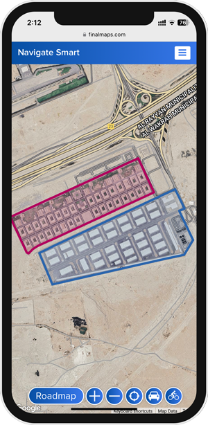
Customized Map
| |
Customizable map (Locations, Areas, Colors, Information) |
| |
Unlimited number of Points, Places, Areas, Images and Data |
| |
Interactive, Flexible and Smart |
Turn your geographic data into powerful insights with Final Maps interactive maps, and Share or Integrate it into website / mobile app
At Final Maps, we specialize in developing innovative geographic websites and applications that help businesses harness spatial data to enhance their operations and make better marketing.
Interactive Geographic Website / Mobile App Development:
We specialize in developing fully integrated websites that rely on interactive maps and Geographic Information System (GIS) technologies, enabling visitors and users to easily explore and analyze geographic data. Our services include:
- Designing and developing interactive user interfaces: We offer flexible and responsive designs that adapt to various devices, providing an exceptional user experience.
- Geographic content management: We offer solutions for managing content related to spatial data, enabling users to easily control the information displayed.
Uses
- Can be printed as a QR code.
- Can be sent as a link.
- Can be embedded in your website and mobile app.
Live Monitoring
A
Live Monitoring System is Cloud App that helps companies efficiently monitor and manage their fleet of vehicles / staff. The system tracks vehicle movements, and manages drivers.
Key Features:
- Real-time location tracking: The system accurately tracks vehicle locations using GPS, allowing companies to know where each vehicle is at any time.
- Driver management: Companies can monitor driver performance and behavior on the road to ensure safety and optimize performance.
- Reports and analytics: The system provides comprehensive reports on fleet / staff performance, helping management make data-driven decisions to improve operations.
Why is it important?
A
Live Monitoring System helps companies enhance the efficiency of their fleet / staff, reduce costs, and ensure compliance with regulations and standards. It can be used across various industries, such as transportation, delivery, logistics, and more.
Consulting
Consulting and Custom Map Solutions:
No two projects are the same, and we understand that your needs may be unique. That’s why we offer specialized consulting services to help you effectively leverage geographic data. Our services include:
- Needs analysis and solution delivery: We work with you to identify your goals and geographic needs and deliver the appropriate solutions to meet those needs.
- Project planning: We assist you in planning and executing complex geographic projects from concept to full implementation.
- Training and support: We offer customized training sessions for your team to ensure they make the most of the geographic technologies we provide.
- Performance evaluation and continuous improvement: We provide services to assess the current performance of your geographic solutions and offer recommendations for continuous improvement.
With this comprehensive and detailed approach, your company’s offerings are clearly communicated, emphasizing the value you can add to your clients through customized geographic solutions.
Custom Geographic Applications:
We develop mobile and desktop applications that rely on GPS technologies and embedded maps to meet your unique needs. Our services include:
- Location tracking applications: Whether it’s for tracking vehicles, assets, or field teams, we provide custom applications that allow you to monitor movement and location in real-time.
- Field team management applications: If you need to organize fieldwork, we provide solutions for scheduling tasks, tracking achievements, and delivering instant location-based reports.
Why Final Maps?
- Extensive Experience: Our team includes specialists with deep expertise in geography and information technology.
- Custom Solutions: We tailor our services to meet your specific requirements.
- Latest Technologies: We utilize cutting-edge technologies to ensure your product is advanced and sustainable.
- Ongoing Support: We provide continuous support from planning to implementation and beyond.
Geographic Data Integration:
Geographic data can be a crucial part of your business success. We assist you in integrating geographic data with your existing systems to improve workflow and location-based decision-making. Our services include:
- GIS integration with other systems: We provide solutions to integrate Geographic Information Systems (GIS) with databases and project management systems, offering comprehensive and unified data.
- Spatial and temporal data analysis: We offer data analysis services that link location and time to understand spatial changes over time and make informed decisions.
- Big Data management: We provide solutions for managing and analyzing large-scale geographic data that help you improve efficiency and planning.